Crews make gains on Bernard Fire

While the Bernard Peak ire continues to creep west toward a control line constructed by crews and heavy equipment, U.S. Forest Service officials report the fire is now 65% contained.
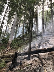
(Photo courtesy U.S. FOREST SERVICE)

The West Branch Fire, located about 9 miles due west of Coolin and about a half-mile west of the Idaho-Washington state line, has grown to about 60 acres.
BAYVIEW — Fire crews made significant gains on containing the Bernard Peak, with U.S. Forest Service officials reporting the fire is now 65% contained.
The fire, located near Bernard Peak near Bayview, is about 1,380 acres in size. The fire, which is human-caused, is under active investigation.
The fire continues to creep west toward a control line constructed by crews, who are continuing work to complete and improve the lines. The fire has been checked on the north side of the West Gold Creek drainage and control lines on the southeast and east sides are mostly secure, U.S. Forest Service officials said in a press release. Crews and equipment continue improving the shaded fuel break and structural protection by Lakeview and a Type 1 Chinook helicopter is still dipping water from Echo Bay for bucket drops.
Over on the western edge of the county, the West Branch Fire also is under investigation. The fire, located about 9 miles due west of Coolin and a half-mile west of the Idaho-Washington state line, is approximately 60 acres in size.
The fire continues to slowly back downhill toward the west branch of the Priest River and is moving slowly uphill toward Forest Service Road 1094. Crews and a helicopter worked through the weekend to contain a small spot fire above FSR 1094.
Significant precipitation is expected in the latter half of the week, starting Wednesday with up to one inch of rain predicted.
Area residents should be aware of fire engine traffic on Forest Service Road 312, also known as Squaw Valley Road. Also, residents are reminded that if drones are flown over a fire, air operations could be suspended until the risk of a mid-air collision with a drone is resolved.
"When firefighting aircraft are grounded for any reason, fire crews lose access to a valuable resource which can adversely affect the safety and efficiency of the overall firefighting effort," Forest Service officials said.
For those curious about fire containment and what it means, Forest Service officials said containment is based on the percent of the fire perimeter — not acreage — that is contained by a defensible line.
"This can be a waterway, any other natural barrier, a road, or a fireline," Forest Service officials said in the release.
Combined with favorable weather, aviation support, and firefighter actions on the ground, firelines — a hand- or equipment-built strip of ground where all burnable materials are removed to stop a fire from spreading — help limit new fire growth.
However, a fireline by itself, however, does not equal containment, the officials said.
"Fire managers cannot call an area of line contained if there is any chance it could ‘come back to life’ and allow the fire to cross the fireline," they said. "In fact, crews monitor all fireline for several days and work to put out burning stumps and ash-pits near the line, while checking by hand for heat."
Caroline Lobsinger can be reached by email at clobsinger@bonnercountydailybee.com and follow her on Twitter @CarolDailyBee.