Crews making progress on fires
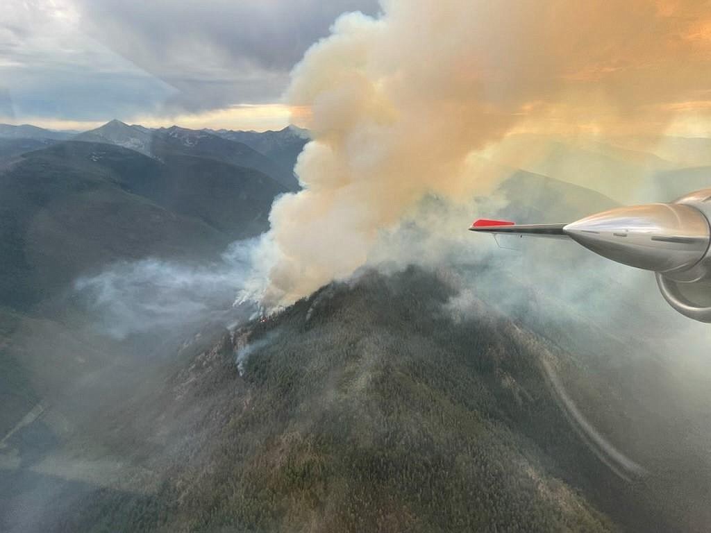
A view from above the Long Canyon Fire as it burns towards the ridge top.
(Photo courtesy USDA FOREST SERVICE)
BONNERS FERRY — Completion of efforts aimed at bringing the Kootenai River Complex fires under containment have reached 85 percent.
Fire management responsibilities for the fires are being assumed by the local ranger district effective Saturday. Crews spent the day shadowing the Eastern Area Incident Management Team to be ready to take full control, officials said in a press release.
Fires on the complex have burned an estimated 22,482 acres since they were sparked by lighting in mid-August.
Air resources are monitoring activity on the Long Canyon fire since its unexpected growth on Wednesday and will determine needed action, officials said. In addition, crews will begin assessing structures along Smith Creek Canyon.
Crews are continuing suppression repair efforts where safe to do so.
"There is an opportunity for crews to put in a new dozer line that will connect two sections of existing line in the Farnham area," officials said. "Along Westside Road firefighters will be patrolling fire control lines, testing and maintaining structure protection equipment, and mitigating hazard trees and snags."
Boulder Mountain Fire
The Washington Department of Natural Resources and Colville National Forest is monitoring the Boulder Mountain Fire. The fire, which has burned 2,310 acres, has been contained to 99% contained.
While the Colville National Forest has lifted a closure enacted for the duration of the fire, officials warned that many natural hazards can exist for months – if not years – after a fire is out, including unstable dead or dying trees, burned out root systems and unstable soils.
Diamond Watch Fire
The Diamond Watch Fire is 60% contained, fire officials said in a press release.
Since started by a lightning strike in mid-July, the Diamond Watch fire, has burned 1,220 acres. Located 5.5 miles due west of Nordman, the fire has 1g fire personnel assigned to the fire.
Columbus and Bear Gulch Fires
The Columbus Fire, started by a lightning strike in August, is straddling the Idaho/Montana corner near the Columbus Creek drainage.
Located 6 miles northeast of Murray, the fire has burned 2,298 acres and is 0% contained.
Located 6 miles east of Murray, the Bear Gulch Fire has burned 144 acres since being sparked by lightning in mid-August. The fire is within a mile of the Idaho/Montana border with terrain similar to the nearby Columbus Fire.
Fire officials expect containment of the fire by the end of October.
Thor Fire
The Thor Fire — along with the Slate, Salmo and Gypsy Ridge fires — is burning in an area where the fire activity does not pose a threat to any “values at risk,” including wildlife habitats, watershed areas, natural resources, recreation infrastructure, or private land.
The largest of the fires, the Thor Fire, has burned 1,300 acres; the Slate Fire, 620; Salmo, 320; and Gypsy Ridge, 17.
Closure, evacuations and information
• On the Kootenai River Complex, the following Forest Service trails and roads are closed: Ball Creek Road (FR 432), Trout Creek Road (FR 634), Russell Mountain (No. 12), Russell Ridge (No. 92), Ball and Pyramid Lakes (No. 43), Pyramid Pass (No. 13), Pyramid Peak (No. 7), Fisher Peak (No. 27), Trout Lake (No. 41), McGinty Ridge (No. 143), Clifty Mountain and Clifty/Burrow (No. 182), Myrtle Peak Trail (No. 286), and Burton Peak Trail (No. 9). Westside Road is limited to residents only.
• On the Diamond Watch Fire, closure orders are in effect for Forest Service roads 311, 308, and 1362H in the vicinity of the fire. However, FSR 1362 remains open. Petit Lake and is associated campsites are within the closure area.
Some camping areas along the southwest portion of Sullivan Creek Road have been notified that they are on a “set” be ready evacuation status and should be ready to leave if asked by local authorities.
• On the Coeur d'Alene Ranger District, closures include Trail 148 along Casper Creek, Trail 7 from the intersection with Trail 774 to Thompson Pass, Trail 1107 near the state line, Trail 763 near the state line, Forest Service Road 938, FSR 430 and FSR 604CZ.
• All methods of travel are prohibited (foot, mechanized, motorized and stock) on the closed roads and area.
• A temporary flight restriction is in place on the Katka Fire as well as on Scotch Creek, Russell Mountain, Eneas Peak and Trout fires. As a reminder, civilian drones are not allowed around active fires. Flying drones near an emergency scene is against the law and forces fire crews to ground their flights.
Information: InciWeb.nwcg.gov