Redistricting commission approves new legislative, congressional maps

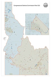
Idaho’s bipartisan redistricting commission approved a new legislative map, pictured above. All of Boundary County and most of Bonner County, with the exception of the Blanchard and Spirit Lake areas, would remain in the new District 1.
(Courtesy of IDAHO COMMISSION FOR REAPPORTIONMENT)

Idaho’s bipartisan redistricting commission voted 4-2 to approve a new congressional map which splits Ada County but divides Idaho’s population in half.
▶️ Listen to this article now.
Idaho’s bipartisan redistricting commission approved a new congressional map and a new legislative map Friday afternoon at the Idaho Statehouse, wrapping up a significant chunk of the group’s work ahead of the Nov. 30 deadline.
Commissioners voted unanimously, 6-0, to approve the new legislative map, which is titled L03. Commissioners then voted 4-2 to approve the new congressional map, which is called C03.
If approved, all of Boundary County and most of Bonner County would remain in District 1. A southwestern portion on Bonner County —encompassing the Spirit Lake and Blanchard areas — would be moved into the new District 2. Areas on the southeastern portion of the county, including Sagle, would be moved from District 7 into District 1.
Under the map, current District 1 Sen. Jim Woodward and Sage Dixon, representative for current District 1B seat, would remain in the newly configured District 1. Heather Scott, representative for the current District 1A seat, would be in the newly configured District 2.
The redistricting process looks at what is best for residents, such as community ties and maintaining those relationships. Where current representatives live is not considered in the equation, Woodward said.
"The process doesn't consider the location of incumbents," he said. "The process looks at how best can regular citizens be represented."
The commission comprises three members appointed by Republicans and three by Democrats. It took a minimum of four votes to approve a map.
“That was a lot of work,” commission co-chairman Dan Schmidt said after the final vote.
Redistricting takes place every 10 years and is the process of using new U.S. Census Bureau data to redraw Idaho’s 35 legislative districts and two congressional districts to ensure political representation is as equal as possible. Idaho was the second-fastest growing state in the country over the past 10 years, according to the 2020 census. But that growth was uneven and divided, which is why the old political boundaries needed to be tossed out and redrawn.
The process is required by the U.S. Constitution and the Idaho Constitution. Similar redistricting processes are playing out in states across the country now.
Commissioners first convened Sept. 1 and spent much of the fall traveling across Idaho to hear from residents during 18 public hearings where a cumulative total of 241 people testified. Schmidt said he borrowed his daughter’s hybrid vehicle and put 6,000 miles on it traveling to all the meetings.
As expected, there are already questions about and pushback to the maps. Republican legislative leaders issued a written statement shortly after the vote to approve the maps.
“The Idaho House Republican Caucus is not entirely thrilled with the new reapportionment of Idaho’s legislative map,” said Speaker of the House Scott Bedke, R-Oakley, said in the written statement. “In some cases, highly-qualified and established legislators may be forced to campaign against equally skilled former colleagues. It’s an unfortunate situation and will result in the loss of considerable talent and dedication to service to the people of Idaho, but we understand the Commission for Reapportionment was working under a tight window and appreciate their efforts to complete this task in a timely manner.”
Earlier this week, the Ada County Commission, Canyon County Commission and Shoshone-Bannock Tribes also expressed opposition to a previous version of the legislative map. In each case, they were unhappy with how their local communities were split up by the proposed map, which is similar to map L03 that commissioners adopted.
New congressional map splits Ada County, divides Idaho’s population in half
Commissioners Bart Davis, Eric Redman, Tom Dayley and Amber Pence voted to approve the congressional map, while commissioners Schmidt and Nels Mitchell voted against it.
Schmidt and Mitchell told the Idaho Capital Sun that splitting Ada County between the two congressional districts was one of the reasons they opposed the map.
“To me that is in statute, we swear an oath to serve the state of Idaho and follow the statutes, follow the constitution,” Schmidt said. “We should follow it.”
Schmidt added that he would like to see the Legislature “clean up” redistricting laws.
On Thursday, Schmidt had advocated for a map that didn’t split any Idaho counties. Meanwhile, Davis said Ada County had been split between the two congressional districts for the past 50 years and he was able to help draw map C03 so that the population of both districts is the same, at 919,553.
“There are honest disagreements on the congressional plan and that’s the reason we have a commission of six; it’s to allow us to think about it and challenge each other’s thinking and hopefully come to a resolution as I believe we have today,” Davis told reporters after Friday’s vote.
“I am not a fan of the expressions that we want to somehow divide Ada County for the purpose of diluting their voice; I feel just the contrary,” Davis added.
With the split of Ada County, most of Boise remains in the second congressional district. Just 3,752 people residing in the southwest corner of the city will be in the first congressional district. Boise had a population of 235,684 according to the 2020 census.
Legislative map wins unanimous approval
Idaho’s new legislative map, L03, divides the state into 35 legislative districts by splitting up eight Idaho counties. Based on the 2020 census population, the ideal size for an Idaho legislative district is 52,546. The L03 map has a total population deviation of 5.84%, ranging from -3.77% below the ideal district population to 2.07% above the ideal population of 52,546. Commissioners sought to keep that deviation low, and were told by staff that a plan with a deviation of 10% or more would presumably be unconstitutional.
Mitchell said he is proud of the legislative map and believes the commission’s unanimous vote is a testament to its quality.
“The final version strikes the right balance,” Mitchell said in an interview. “All of the districts are pretty close to parity in terms of population. In addition, we tried to minimize moving districts entirely.”
“Overall with the Treasure Valley, I think we did a much better job than has been done in the past recognizing city boundaries,” Mitchell added.
Commissioners work not finished
Commissioners will meet at least once more to vote on an overall redistricting plan. That meeting is scheduled for 1 p.m. on Nov. 10, but could change, commissioners said Friday.
The maps and overall plan will then be submitted to the Secretary of State’s Office and reviewed by the Idaho Attorney General’s Office.
The redistricting commission also expects to post detailed versions of the approved legislative and congressional map on its website by early next week. The commission’s staff also launched an online tool that allows Idahoans to enter their address to find out which legislative district they will be in.
If the maps survive any potential legal challenges, they will remain in place for the next 10 years and determine which congressional and legislative candidates Idahoans will be able to vote for and, therefore, who will represent them and their neighbors in Congress and the Legislature.
Commissioners and the commission’s staff have been pretty blunt that they expect some sort of legal challenge, based on historical redistricting processes.
Daily Bee reporter Caroline Lobsinger contributed to this story.